
Former Hurricane Hilary Threatens Rare Tropical Impact on Los Angeles with Heavy Rain, Gusty Winds, and High Surf.
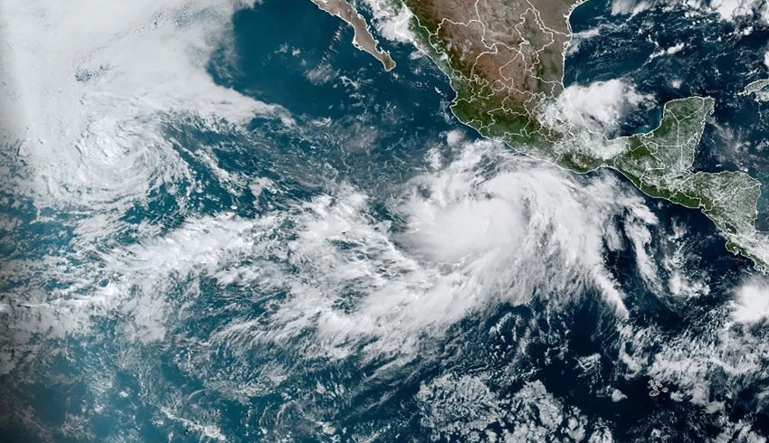
In an unprecedented turn of events, the city of Los Angeles might face the impact of a former hurricane this upcoming weekend. The weather phenomenon, Hurricane Hilary, is currently positioned off the coast of Mainland Mexico as Tropical Storm Hilary. However, forecasters predict that it will evolve into a hurricane by 1 p.m. on Thursday and escalate to a major hurricane with a Category 3 classification or higher by 1 a.m. on Saturday. As Sunday approaches, Hilary is projected to weaken slightly before reaching Southern California, potentially affecting Los Angeles as a tropical storm.
A Historic Potential
The prospect of a full-blown tropical storm making landfall in California has been exceedingly rare throughout history. Only one such event has been recorded: the Long Beach tropical storm in 1939, which struck near San Pedro. Notably, California has never experienced a landfall of a tropical cyclone with hurricane intensity. This protection can be attributed to colder sea surface temperatures and upper-level steering winds in the eastern Pacific that mitigate the conditions conducive to hurricane formation and intensification.
However, this year’s El Niño event has led to abnormally warm ocean temperatures, with Malibu’s coastal waters registering a surprising 70 degrees Fahrenheit. Typically, the warmest coastal ocean temperatures in Los Angeles during the summer range between 67 to 68 degrees Fahrenheit. This unusual warming of the waters could potentially provide the fuel needed for a tropical system like Hurricane Hilary to gain strength.
Uncertain Tracks and Rainfall Projections
Predicting the precise path of a hurricane remains a formidable challenge, especially several days in advance. The latest forecast from the National Weather Service (NWS) suggests a significant spread in the projected track of Hurricane Hilary, leading to a low-confidence forecast in terms of both its trajectory and impacts. Despite this uncertainty, the majority of the Global Ensemble Forecast System (GEFS) ensemble members anticipate moderate to heavy rain amounts, particularly south of Pt. Conception.
The anticipated rainfall for Southern California during this period is notably substantial for summer conditions. The NWS indicates the possibility of rain accumulations exceeding 2.5 inches, with some forecasts reaching up to 2.9 inches. This points to the increasing likelihood of an anomalous rain event. As of now, the official rain total forecast spans approximately 1 to 2 inches across the region from Sunday through Tuesday, although the actual track of the storm could lead to much higher or lower amounts.
Secondary Hazards and Coastal Impact
Aside from heavy rain, Hurricane Hilary’s potential impacts include lightning, which, if accompanied by wind but without rain, could elevate the risk of fire. Furthermore, waves and marine conditions are expected to be significantly affected. The NWS warns of hazardous marine conditions along coastal waters, driven by Hilary’s presence. The storm’s long-period, steep, southerly swells could result in high surf and dangerous conditions.
Current estimates from Surfline predict waves of 4 to 5 feet in Northern Los Angeles County and 6 to 8 feet in Northern Orange County. However, these estimates are subject to rapid changes within a 24-hour period based on the storm’s movement. Recently, Surfline forecasted an extraordinary 15 to 20 feet of surf in Northern Los Angeles County, which, if realized, would mark an exceptional event for the region during the summer months.
Forecast Overview and Precautions
As of now, Tropical Storm Hilary is in the process of strengthening and is projected to move northwest, roughly parallel to the coast of Mexico. It is expected to pass west of the southern tip of Baja California on Saturday morning. However, the range of possibilities in terms of the storm’s trajectory and impacts remains wide, leading to a cautious and low-confidence forecast.
Residents and authorities are urged to closely monitor the situation, especially those residing near burn scars where isolated flooding could be a concern. Gusty winds may also accompany the storm, potentially leading to “wet” Santa Ana wind conditions on Sunday. The coastal areas, particularly south-facing harbors like Avalon and Long Beach, are also at risk due to the anticipated increase in south-to-southwest swells.
The storm is forecasted to leave the area by Tuesday, but lingering southeast flow aloft may maintain a chance of showers throughout the following week. As Hurricane Hilary approaches, staying informed and heeding any evacuation or precautionary measures issued by local authorities is crucial for the safety of all residents in the potentially affected areas.
Author